Home > Mountains > Wasatch > North Fork Park Winter Recreation  
  North Fork Park - Winter


Backcountry Skiing, North Fork Park, Utah
Photo: Dave Banks
Distance: 1-3 miles
Time Needed: 1-4 hours
Rating: Easy
North Fork Park Elev: 5,740 ft
Elevation Gain:: 300 ft
Maps: USGS 1:100,000 Ogden

Attractions
Location: beneath Ben Lomond Peak in Ogden Valley just north of the town of Liberty.

This is another good area for snowshoeing, beginner cross country skiing, telemark skiing and winter camping...without the crowds. I went in mid-February on President's Day Weekend, and few people were there. Also, this area had lots more snow than similar elevation areas near Salt Lake (which basically had none). At least several miles (probably much more) of Park/Campground roads are groomed or packed by snowmobiles, making for easy gliding. Side roads would also make a fun area to "practice" winter camping or snowcave building skills. The slopes of Ben Lomond / Willard Peak adjacent to the Park offer immediate areas for intermediate to beginner telemark skiers. Finally, for the more adventurous and very experienced (e.g, avalanche precautions), I'd bet a ski or snowshoe trip up to the summit ridge, or Ben Lomond Peak itself, would be awesome.


Driving Directions

You'll be driving on paved, plowed roads the entire way. From Salt Lake City, take I-15 north approximately 41 miles to the 12th Street Exit (#347) in North Ogden. At the end of the exit, turn left onto Hwy 39 and travel through Ogden Canyon about until you come to Hwy 158 and the Pineview Reservoir Spillway. Turn left on Hwy 158 and cross the reservoir spillway, following the brown recreation signs to Wolf Creek and Powder Mountain. Wind around the reservoir until you reach a fork in the road. Veer to the left here, staying on Hwy 158. You will come to a stop sign. Turn left here onto Hwy 162 and drive north for about 3 miles, turning left on 4100 North. Almost immediately, take the first righthand turn, onto 3300 East (signs point up this road to "North Fork" and "Avon"). In 1.8 miles, turn left on the North Fork Road. One mile later turn left on 5950 N. at a sign that says Ben Lomond Trailhead and North Fork Park. You'll reach another intersection with a road coming in to your left -- just go straight ahead to the car park. It's not a huge parking lot, but for such a lightly-used area, you shouldn't have any problems finding a spot. Light-duty cars should be just fine other than maybe getting muddy -- the lot is just dirt, but it's plowed.

Trail/Route Notes
From the Parking Area, just head due west toward the mountain. The roads more than likely will be groomed or packed by snowmobiles (luckily this area doesn't seem to be overrun by them). In about 10-15 minutes you'll reach an "intersection" of sorts. Generally speaking, you don't need much more guidance -- either head for the slopes, or follow the roads wherever you feel like. But here are my notes on the area...

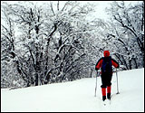
Telemark Skiing or Snowshoeing: Going straight ahead towards the mountain for about 10 minutes brings you to a Trailhead sign. The Great Western Trail runs through here as well (profiled on the trailhead map), going up to the summit ridge and down the Skyline Trail to North Odgen Pass. From the Trailhead, I followed existing snowshoe/ski tracks upslope for about 1/2 to 3/4 mile (about 300 ft elevation gain), to a nice north-facing slope and got in a few turns, in excellent powder snow considering recent warm weather and elevation. The tracks followed the summer trail route, which probably is the easiest and safest way to go up, especially if you're headed up higher.

XC Skiing or Camping: At the intersection, the main road runs north/south right at the base of the mountain. Going left (south), the road goes over steeper/more hilly terrain. Going right (north) had more gently sloped roads. I skiid up this northerly road for an hour before turning around, but the road appears to keep going for a good while. Also about 45 minutes up the road another side road takes off to your left, going up a small side canyon. This might be an excellent out-of-the-way winter camping area. I imagine there are other similar places further up the road as well.

For more info on trails in the area, contact the U.S. Forest Service at (801)625-5306.


 Recommended Book
Hiking UtahWasatch Winter Trails

A solid guide for beginner to intermediate level skiers and snowshoers. If you've always wanted to experience the peace, solitude, and beauty of winter backcountry travel in the Wasatch, but didn't know where to go, or how to do it safely, get this book.

Get it at Amazon.com

More books about Utah mountains

 More Wasatch
 Utah Mountains
Highest Peak in Each County
Great Western Trail
Uinta Mountains
Wasatch Range
Northern Utah Mountains
Central Southern Mountains
Isolated Ranges

Landform Map of Utah
 Site Categories