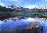
Other than the Brooks Range in Alaska, the Uintas are the most prominent east/west range in the United States. The entire range encompasses a huge area but most backpackers planning more than an overnighter focus on the central portion of the range in the High Uintas Wilderness Area. Glaciers have created large alpine basins filled with hundreds of lakes, and surrounded by magnificent peaks that reach up to 13,528 at Kings Peak, the highest point in Utah.Wildlife abound - moose and elk are commonly seen, but more elusive mammals such as black bear, bobcat, and fox live in the Uintas as well.
This is one of the more remote lakes, a bit harder to access .. but you'll enjoy incredible mountain backdrops and fewer people.
Uintas Hiking Tips
·
Always take rain gear during the summer months. Afternoon thundershowers are especially common.
·
The High Uintas are notorious for biting insects. Take insect repellent, or go during September when most mosquitoes are gone.
·
Because firewood is getting scarce, most notably in the upper elevations, it's best to take a lightweight backpacking stove for cooking.
·
Be wary of the thin air. Sure, this isn't the Himalayas, but altitude sickness is very possible above 9,000 to 10,000 feet.
·
Use sunscreen! Maybe it's being a few thousand feet closer to the sun or maybe it's the thin air, but the high altitude will hand you a beet red sunburn in no time flat if you aren't careful.
·
Bring warm clothing -- freezing temperatures are possible any time of year.
·
Bring a good map and compass as the trails in the upper basins can be hard to find.
·
Before mid-July you'll likely run into big snowfields and torrential streams, but even in late summer you may want to take wading shoes.