Home > Mountains > Wasatch Range > Lone Peak Summit  
  Hiking to Lone Peak Summit


Rainbow Bridge
Total Distance: 9 miles round-trip
Time Needed: 1 day, overnight an option
Rating: Difficult
Starting Elevation: 5,200 feet
Summit:: 11,253 feet
Maps: USGS 7.5" Maps: Lehi, Draper and Dromedary Peak; USGS 1:100,000 Maps: Provo and Salt Lake City


Introduction

Located in the heart of the Lone Peak Wilderness Area, the Lone Peak summit is rather unique in the Wasatch. It features jagged, gray granite composition, unlike any mountain in Utah, really. The sheer 650+ foot face is a classic rock climb (not described here), a favorite of climbers willing to make the rugged (and in the summer, hot) approach. Spectacular and easily accessed, the Wilderness Area even has a few lakes, the most well known of which is Lake Hardy.
Directions to Trailhead

From I-15, take the Alpine/Cedar Hills/Highland Exit (#287) and turn onto UT-92 going east. Turn left/north on 5300 West (Alpine Highway), which eventually becomes Main Street. Turn right on Pioneer Road (600 North). You'll then merge with Grove Drive; turn left. Grove Drive makes a sharp, 90 degree turn to your right. Just before a tall chain link fence with large boulders in front, turn left onto Alpine Cove Drive. Then turn left onto Aspen Drive. This street ends at a rough dirt road with a gate, which, according to a sign is "open 7am-10pm."

No camping allowed in this area past the gate, but there is plenty of parking. I'd recommend parking by a large water tank. If you have a 4WD vehicle, you can continue driving up the road and find precarious parking on the mountainside at the "real" trailhead. I'll assume you're going to park down lower.

NOTE: Trailhead access is through a fast-growing subdivision of Alpine, so the precise trailhead location may have changed by the time you read this (written 7/10/00).

Route/Trail Notes

From the parking area, follow the dirt road northeasterly along the base of the mountain. The road will make an abrupt almost 180 degree turn to the left as it begins climbing the hillside. After switchbacking many times, you'll reach a gate (private property). At this point, you'll leave the road and head almost straight up the mountain on a trail. There should be a Forest Service sign here, marking the detour trail, pointing up to the "Lone Peak" area.

Avoid doing this part of the trail midday. It's the toughest part of the climb. The trail shows no mercy, with no switchbacks, going directly upslope through loose gravel and oakbrush. You'll eventually meet up with the road again, having bypassed the private land. Immediately thereafter you'll reach the wilderness boundary...and interestingly, a noticeable transition -- a beautiful meadow and stream, as if to herald the beginning of wilderness. The meadow is sometimes called the "First Hamongog".

In the meadow, the trail veers left into the trees, and climbs steadily for almost a mile to another meadow, the "Second Hamongog". There is great camping adjacent to this meadow, with shaded, level sites, and water nearby. There is a trail junction in the middle of the meadow -- one trail goes right towards Lake Hardy (#176), and another, straight ahead to Lone Peak Cirque (#186). If you're still planning on the summit go straight.

The trail goes more or less straight up again. It's quite steep, but this time it's in more pleasing terrain with great views of both the valley and surrounding peaks. You'll also likely find water running alongside the trail, with wildflowers. The higher you go, the more the trail fades; follow the cairns. NOTE: If you want to go to the Lone Peak Cirque (to rock climb or camp, etc), just keep following the cairns heading westerly around a ridge.

To keep going directly to the summit, eventually you'll have to leave the trail (cairns) and routefind to the top of the ridge directly above you. Use your best judgment to find what looks doable and safe, since the terrain varies from exposed cliffy sections to just plain old steep scrambling. For the average person, I'd recommend aiming for a lower part of the ridge, to your right. Once on the ridge, you'll find easier, less-steep walking to the top.

The first highpoint you see from the 2nd Hamongog isn't the summit. It's just the ridgetop, likely the "west" summit. If you walk to that point, you can see the real summit as well as the sheer granite face... and the 600 foot drop beneath your feet to the cirque.

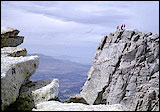
You'll also notice that the highest point, the true summit, is the northernmost point, across a short but exposed and jagged ridge (you wouldn't be the first person to opt not to walk across it). From both summits the views are spectacular and the near vertical drop to the cirque below is dizzying. A very worthwhile climb.

Other Tips/Notes


Start this hike early in the day, as the lower route is hot and dry.

This is a very demanding hike -- not for beginners. Be prepared with enough food, water, time and energy.

Camping at the 2nd Hamongog would make this a nice 2 day trip.

Lake Hardy is another good camping area. Just be aware it's a long, steep haul, and quite a distance from Lone Peak summit. Better for a destination in and of itself.

Bring the usual -- map, compass, sunscreen, and a parka for the cool, windy summit.

Summer hiking is from early July to about end of September.

 Recommended Books
Hiking UtahHiking Utah
The 75 hikes in this guide cover the entire state, including Lone Peak. Each hike gets two-three pages including directions to the trailhead, maps needed, special attractions, best season, where to get more details, and instructions on the route to follow.

>>Get it at Amazon.com

Hiking UtahUtah's Favorite Hiking Trails
A highly rated book, useful for anyone planning a hiking trip in Utah. Contains detailed maps, hike ratings and numerous black and white and some color photographs.

>>Get it at Amazon.com

>>More books about Utah mountains

 More Wasatch
 Utah Mountains
Highest Peak in Each County
Great Western Trail
Uinta Mountains
Wasatch Range
Northern Utah Mountains
Central Southern Mountains
Isolated Ranges

Landform Map of Utah
 Site Categories
 To Do

High Uintas Guidebook
Click For Info

A Guide to Climbing the 13,000-Foot Peaks of the High Uintas