Home > Desert & Canyon > San Rafael Swell > Chute of Muddy Creek  
  Hiking the Chute of Muddy Creek


Wading Muddy Creek
Total Distance: 15 miles one way
Time Needed: 1-2 days (not incl. driving time)
Rating: Moderate to Difficult
Starting Point:: 5,100 feet
Elevation Drop 300 feet
Maps: USGS 7.5" Hunt Draw and Tomsich Butte; USGS 1:100,000 San Rafael Desert

Introduction

Isolated, rugged canyons with lots of wading in cool water and spectacular narrows characterize Muddy Creek.  One of the premier canyons in the San Rafael Swell, it features an amazing log jam over 25 feet above your head, and a section with wall-to-wall water six feet deep during spring runoff. Summer hiking offers the chance to cool off in the canyon's shady, low-level waters (if you can stand the bugs).
Directions to Trailhead

From Salt Lake City, drive south on I-15 and take Exit 222 (just after Nephi). Continue south on Hwy 28 to Salina and get on I-70 going east. Leave the freeway at Ranch Exit 129. Turn right on a dirt road which parallels the freeway (going west) before turning sharply south. After about 10 to 15 minutes a road comes in from the right but continue straight. After this junction just follow the signs to Red Canyon or McKay Flat -- either road will get you to the Hondoo Arch camping area (the hike's beginning. If in doubt take the right forks. Either road will get you to the Hondoo Arch camping area (the hike's beginning).

To Leave Transportation at End of Hike: Take the McKay Flat road and turn south at the Hidden Splendor Mine sign. After a descent of a red-rock cliffed area, you'll find the mine marked by a metal tank (on left) and a debris mound. This is the end of the hike; leave bikes or vehicles here.

Driving Time: From SLC to I-70 Exit 129 is about 3.5 hours. From Exit 129 it's 1 to 1.5 hrs to the Hidden Splendor Mine, and from the mine 45 min. to Hondoo Arch. The dirt roads are well-graded and suitable for light-duty vehicles unless muddied by rain.

Route/Trail Notes

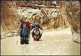
This is not a loop hike so you'll need to leave a car or mountain bikes at the end of the hike to get back to the beginning. The route begins at the Hondoo Arch camping/flat area, at the end of either the McKay flat road or the Reds Canyon road. You can find cattle trails in much of the canyon but for the most part you are picking your own route, choosing where and when to cross the creek. You can't get lost, however, as you simply follow the creek down canyon. The further you go the more time you'll be spending in the water so it's best to just put your wading shoes on from the beginning and enjoy the water.

In about 4 to 5 hours you'll reach a very deep section of the creek -- some guidebooks don't mention this pool, which makes it seem likely its creation was a fairly recent occurrence. During spring runoff the water in this pool can be up to neck deep (or higher!) in it's deepest parts and chest deep through the rest. By mid-summer the water here should be much lower. This section is about 50 feet long and is unavoidable. Adventurous hikers will find this one one of the highlights of the trip. Except for this one deep pool, Muddy Creek at it's deepest should only be thigh-high in spring runoff and calf-high in the summer.

In 20 more minutes you'll reach the log jam. About half an hour past the log jam the canyon begins to widen, signaling the end of the Chute. About an hour more and you'll reach the entrance to Chimney Canyon, easily identified by two huge boulders on opposite sides of Muddy Creek.

An hour from Chimney Canyon, keep an eye out for a rough but well-defined road going up a cliff on your left. Go up the road to the Hidden Splendor Mine where you've hopefully left a vehicle or bikes. Drive or bike back to Hondoo Arch (16 miles, with a 1700 foot gain the first 7 miles).

Hiking time varies drastically depending on the amount of water in the creek, the fitness of the hikers, lunch breaks, Kodak moments, and the weight of your packs. All times listed above are assuming you're in relatively good shape, carrying only day packs, and keeping a steady pace. If this is the case plan on about 6 to 7 hours hiking time (not counting breaks) from Hondoo Arch to the Hidden Splendor Mine. If you're doing this as a one-day hike from Salt Lake City you should drive as close as you can the night before to the hike's beginning and car camp (otherwise you're looking at one VERY long tiring day).

Backpacking:  In high water with heavy multi-day packs and/or a liesurely pace you'll need to watch the time closely and count on up to 11 hours for the whole hike. There are no places to camp in the Chute safely. In other words, you'll probably end up camping at the end of the Chute (~8 hours) or by Chimney Canyon (~9.5 hours). In low-water season backpacking time will be much faster.

Other Tips/Notes


Purchase a copy of Canyoneering: The San Rafael Swell by Steve Allen. An indispensible guide for any San Rafael Swell hike.

For the deep section, put important items in sealed plastic bags. In the spring when the water is the highest consider carrying an inner tube per person for floating packs and/or people. Take a bike pump to inflate the tubes when you get to the deep section.

Do the hike only with a good weather forecast. Flashfloods can occur at any time of the year, but especially during late July through mid-September. The quick cloudbursts from thunderstorms are the deadliest.

Whatever the season a good pair of wading shoes is a must. Don't wear sandals or leather hiking boots, especially on a spring hike. An old pair of running shoes is ideal as they will help prevent painful rocks under the feet and won't weigh you down.

In the deep, muddy water a probe (hiking poles or a found stick) will help you hike faster.

Always be prepared with warm, dry clothing as the canyon bottom can get chilly.

The creek is usually too muddy for filtering or tablets so bring your own water. However, there's a spring area 15 minutes or so up Chimney Canyon if you don't mind a bit of Class 4 scrambling.

If you go during the summer, beware of the possibility of being driven insane by bugs.

 Recommended
CanyoneeringCanyoneering
by Steve Allen

This guide deals with specific hikes/backpacks in the San Rafael Swell. It's probably the most accurate Utah trail guide around. We have now done well over 20 of the trips in this guide, and the trail descriptions were right on every time. It is well-written, clear, and concise.

>>Click here see the book at Amazon.com

>>View pages from Canyoneering

>>More books about Utah's Canyon Country

 Site Categories
 To Do

High Uintas Guidebook
Click For Info

A Guide to Climbing the 13,000-Foot Peaks of the High Uintas