Home > Parks & Monuments > Rainbow Bridge NM > Backpacking Rainbow Bridge  
  Backpacking to Rainbow Bridge


Rainbow Bridge
Total Distance: 13 miles one way from trailhead to Rainbow Bridge
Time Needed: 2-4 days (not incl. driving time)
Rating: Moderate to Difficult
Maps: USGS 7.5" Rainbow Bridge and Chaiyahi Flats

by Marden Clark
Introduction

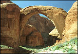
Even with today's ultra light backpacks, tents and sleeping bags, freeze dried food, and sturdy footwear the 13-mile backcountry trail to Rainbow Bridge is an arduous trek. I pity early commercial trips down the canyon, with their dusty mules and shoddy shoes. Yet surely the W.B. Douglas and Byron Cummings Party on their historic 1909 trip was also dazzled by the beautiful red and orange canyons, the sheer cliff walls and the green streambed. Guided by trader/archaeologist John Wetherill, Ute Jim Mike and Paiute Nasja Begay, the party struggled up and down the rugged fringe of Navajo Mountain before making the first publicized sighting of Rainbow Bridge.

This hike can be done as an overnighter, but only by experienced hikers. A beginner will want three or four days to cover the broken terrain. The trail wanders through a number of small canyons, and follows a long, uphill contour to the top of Sunrise Pass for the first four miles. The next mile and a half dive abruptly down an ancient talus slope into Cliff Canyon. The drop is steep enough to turn even the best knees into jelly as you go down. The rest of the hike through Cliff, Redbud, and Bridge canyons is docile except for one steep rise up Redbud Pass.

The Rainbow Bridge Trail is still as hard as it was in 1909, and relatively few people take the trail anymore. Today, most people travel to the bridge by boat on Lake Powell. But if you're willing to strain your legs to see some of Utah's most spectacular canyon country on the way to the crown jewel of Lake Powell, here's a guide from UtahWild.

Directions to Trailhead

From Page, AZ, take State Route 98 about 45 miles to the Navajo Mountain Road turnoff. At the turnoff, go north for 33 miles, half of which is dirt road. At the Navajo Mountain School sign, six miles from the trailhead, take the left fork. After four more miles, you will come to a large sandstone knob, Haystack Rock. Take the right fork between the rock and Navajo Mountain and continue past War God Springs until your reach the ruins of a stone lodge. Once you pass War God Springs, the road becomes extremely rough and four-wheel drive necessary.

PARKING: Without four-wheel drive, War God Springs is as close to the trailhead as you'll want to drive. Otherwise, you can park at your own risk anywhere along the dirt road. (You might want to have extra gas in case your tank gets emptied while you're away.)

Route/Trail Notes

While the trail isn't marked with a sign, once you find what's left of the lodge you will find the trail--it looks like the natural extension of the dirt road.

The trail is easy to follow and well marked with frequent cairns and signs. The biggest obstacles are the several canyon crossings, the talus slopes, and the occasional bayonet yucca that can pierce pants. There are decent camping sites in Cliff Canyon, and about a mile outside of the National Monument is Echo Camp where the old commercial trips would stay.

The hike is dotted with junipers, Brigham Tea, sagebrush, and various cacti. In the canyons, cattails, cottonwoods, and other water plants mingle with the typical desert flora carving a swath of shimmering green between the sandstone fins. Ravens, lizards, rodents, and an occasional dog from the reservation are commonly seen animals. At the end of the hike, the huge span of Rainbow Bridge rises 290 feet over Lake Powell, its worn arch of stone (the upper part is Navajo sandstone and the base is the harder Kayenta sandstone) is 42 feet thick and 33 feet wide.

Other Tips/Notes


To hike to Rainbow Bridge, you need a backcountry permit from the Navajo Nation. For information, call the Navajo Nation at (602) 871-6647 or (602) 871-4941; or call the Rainbow Bridge National Monument at (520) 645-2471; or call the Navajo Parks Dept at (928) 698-3360

Backcountry fees: $5 per person entrance fee with a $5 per person per night camping fee

Pack in plenty of water, a filter, or purification tablets. You can find water running down the hike's three canyons beginning with Cliff Springs (seven miles into the hike), but these streams run only seasonally. Lake Powell, near the bridge, provides water year round, but you shouldn't skimp on the purification tablets before using it.

At Cliff Springs, an old outhouse offers the closest thing to "facilities" you'll find on the trail. Otherwise, when nature calls be prepared to answer with a shovel and biodegradable toilet paper. If you camp within 1/4 mile of Lake Powell, you must carry out your waste.

 Recommended Books
Exploring Arches and Canyonlands National ParksExploring Canyonlands and Arches National Parks
by Bill Schneider

Includes directions for many popular hikes, backpacks, and four wheel drives in these parks.� A typical high-quality Falcon guide that offers clear, succinct, reasonable descriptions.
>>Get it at Amazon.com

>>More books about Utah's Canyon Country

 Site Categories
 To Do

High Uintas Guidebook
Click For Info

A Guide to Climbing the 13,000-Foot Peaks of the High Uintas