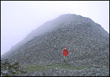
Mount Waas is directly northeast of you. Follow a faint deer trail north up into a sloping valley, just west of Waas. You can sometimes see a weather station on Green Mountain. As you enter the talus/scree a faint trail helps. Where you climb up onto the Waas-Green saddle it is steep, but natural gravels and tundra help your footing, and it is a short slope. Once on the saddle, turn east and follow an obvious zigzagging route thru the talus, formed by many other hikers.
Castle Mountain and LaSal Peak are below and north of Waas and can be reached by downhiking from Waas but not many people do this, so don't expect a trail. Castle Mountain does have an obvious old mining trail to the top and is perhaps more interesting if hiked to from Miner's Basin (read on).
Other Hikes From Beaver Basin


Green Mountain: This peak can be easily climbed once on the Waas-Green saddle (a faint trail helps), and it is a short hike over to Pilot Peak, the next mountain to the south. From Pilot Peak, you can drop down onto the Pilot-Dry Peak saddle (Dry Peak is a minor mountain between Manns and Pilot). From the saddle, an old pack trail drops off east towards Beaver Basin. When it crosses a ridge and switchbacks to the south, you can just drop down the slope and soon join an ATV trail which leads you back to your vehicle. This route is visible from above.
Manns Peak: From Beaver Basin you can use the old pack trail (described above) to get onto the Pilot-Dry Peak saddle. A well-used trail skirts Dry Peak around its west side, then climbs up onto Manns Peak, which is the next tallest peak south of Pilot Mountain. Return the same way.
Experts only: Circumnavigate Mount Waas from the Waas-Green saddle. Climb east up to the end of tundra, traverse across tricky and potentially dangerous sliding talus/scree slopes on the northwest side of Waas to the Waas-Castle saddle. Climb Castle and/or LaSal Peak. Climb back up to Waas-Beaver Creek Pk (really a bump east of Waas on a ridge) saddle, and drop down into the bowl east of Waas. Hike down the bowl until you are able to traverse across a boulder field and around the shoulder of Waas on faint deer trails. Follow these trails over to your vehicle. This route can be done (with Castle Mountain only) in 5 hours.
Alternative Routes From Miner's Basin
Driving: Turn off the west side of LaSal loop road (see map) and drive into Miner's Basin (junction is signed). A 4WD high-clearance vehicle is required, but this area is moderately popular and the road is used often. It is 3 miles to the road's end. There is a pond, parking lot, and outhouse in Miner's Basin. The Trans LaSal trail goes north and south from this parking lot.
Longer and more strenuous: Hike on the north half of Trans LaSal trail, which skirts around some private property, then climbs east onto a low saddle between Mineral Mountain and Horse Mountain [OPTION: Instead of Trans LaSal trail, follow the road past the gate and a ranch. It has many windfall trees but passes by some old adits; it reaches the Horse-Mineral saddle next to the Trans LaSal trail.] Hike a steep slope with a faint route south onto Mineral Mountain. Once on Mineral Mountain, hiking onto Green Mountin is fairly easy. Continue down to Waas-Green saddle, then climb Waas.
Long and moderately difficult: Take the Trans LaSal trail south from the parking lot. The creek bed will be on your right, and after a half-mile it crosses the creek. Look carefully for an old mining road going southeast. Turn onto this road. Almost immediately a trail becomes apparent, but there is no junction sign. Follow it as it switchbacks up onto Pilot-Green saddle. There are many windfall trees, but the grade is gentle and the hiking is not difficult. Once on the saddle, Pilot Peak is a short climb south and Green Mountain is a short climb north. Once on Green, drop down onto Waas-Green saddle and follow the trail up Waas. Return the same way or combine with another route for a loop.
Shorter and more difficult: Drop off the Mineral-Horse saddle, east into the major drainage, turn up-canyon, and find the trail up to the Waas-Castle saddle. Getting up to the saddle is quite rough and steep (this route isn't used often). But once you're on top it is quite lovely, and both La Sal Peak and Castle are easy to climb. In fact, this route is better for climbing Castle and/or LaSal Peak than Waas. You could combine this with another route for an interesting loop hike.