 |
 |
|
|
|
|
| Upper Black Box (w/optional loop) |

|
|
|
|
|
Total Distance: 10 miles w/car shuttle, 14.2 miles otherwise
Time Needed: 9-12 hours, depending on water levels
Rating: Difficult
Elevation Loss 600 feet
Maps: USGS 7.5" Mexican Mountain, Spotted Wolf Canyon, Devils Hole, Drowned Hole Draw
Photos of this hike |
by David Rose
Introduction

|
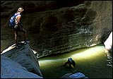
Steve Allen, in his book Canyoneering, calls this hike "Upper Black Box -- A Perilous Journey". To the adventurous, that description makes it a must-do! The hike really is a blast, one of my all-time favorite Swell hikes. The "perilous" description comes from the fact that it's a rough, long hike in a canyon with no easy escape route, where you're constantly wading or swimming in water too murky to see bottom, going through brush, over huge rocks, etc..
We did this hike in June 19, 2002. The notes that follow have to do with our particular conditions. Waterflow was extremely low, basically zero, which not only means in normal years your experience will be different (harder probably), but that you should go soon because the canyon will probably dry up this year. We met hikers who had done Muddy Creek the day before; they said it was completely dry.
This is not a complete hike description -- just notes, tips, and observations based on the hike detailed in Canyoneering.
|
Directions to Trailhead
|
Following Steve Allen's directions, we turned off onto the San Rafael access road (he calls it the "Green River Cutoff Road Section") between mileposts 39 and 40 on Highway 10 out of Castledale.
Just a note that once you're on this road, there were two junctions that were a bit confusing. First, at mile 12.7, there's an "X" road junction. You'll go straight ahead. The other road that veers a bit to the right has the small building that Allen talks about. Second, at the mile 14.9 junction, you'll take the righthand road, which makes an immediate rounded turn, almost pointing you back the way you came. A sign that says "Buckhorn Wash 6, San Rafael Bridge Rec Site 10, and I-70 30" points down this correct road. Just after the San Rafael bridge and campground, you'll turn south (right), on what Allen calls the "Mexican Mountain Road Section".
Update: The Buckhorn Wash Rock Art Panel has been restored, with the vandalism virtually eliminated. They even have sign with photos of before and after. The panel is worth a visit.
Driving Time: From Salt Lake City, it'll take about 3 - 3.5 hours to get to the hike's beginning. |
Route Notes
|
From the car park, there's a track that goes westerly across the flats. However, the route doesn't follow the track, but instead veers to the left across the flats.
A minor detail: most guidebooks mention to watch for the point where the canyon narrows. The narrowing however, seemed very gradual to me. By the time the walls get continuously vertical (as opposed to sloped in places or broken up), coming straight down to a narrow rocky bottom, the drop-off is probably within 15-30 minutes. When you reach it, you've already done most of the hike.
At the drop-off, there was an old rope available at the standard anchor point, but it was almost too awkward to be of much use. We just down-climbed the rocks as far as possible and jumped into the pool. The first person down should try to get down without jumping (bring a rope or webbing) and check for submerged boulders.
The pool that you drop into gets deeper at the far end, so you'll have to swim. After the drop-off and pool, you'll encounter the most wading and narrowest parts of the entire hike. You'll swim in two more places, including one long pool at the end. From the drop-off to the end of the canyon took us only 1.5 hours or less (not nearly long enough!).
At the end of the hike, canyon walls suddenly start getting shorter, until they're maybe 20 feet high, and you'll have to swim (this is the longest pool of the hike). When the walls end altogether, and you see vegetation alongside the river again, take the first obvious exit from the river, to your left. You should see a trail going through the vegetation. The Mexican Mountain Road is perhaps 10-15 minutes away, and you may end up climbing a steep slope to get to it. Turn left onto the road to walk back to your vehicle. It's just a track at this point since the road is closed to vehicles until you reach a berm.
Walking the 4 miles back to your vehicle along the road makes a loop, but if you have two vehicles available, I'd highly recommend doing a car shuttle. The road-walk is a drag at the end of such a wonderful canyon.
|
Other Tips/Notes
|
 |
Finding current waterflow: Check the USGS website for a realtime waterflow chart for the San Rafael River. Or call the Recreational River Report at 801-539-1311. Current flow rates are updated daily for Colorado Basin rivers, which includes the San Rafael River. |
|
Waterflow guidelines: The general guideline is to wait until waterflow is less than 25-30 cfs (cubic feet per second). The waterflow on our hike was 0.36 cfs, almost zero. The telephone hotline in fact said "near zero". In spite of that, there was a nice little stream, and there were still 3 pools too deep to touch bottom, with required swimming. Otherwise, most of the wading was ankle to waist deep. |
|
Weather forecast: You should always go with a clear weather forecast. Low water conditions of course have no effect on the potential for flash floods. Our forecast was for mostly clear skies (10% chance of rain) and hot weather, yet partway through the hike (near the drop-off), a light rain began with dark clouds and thunder overhead -- quite a disconcerting situation, but nothing happened. Our 4 mile walk back along the road to our vehicle was under cloudy skies, with a light rain shower and cool weather (certainly beats walking in 95 degree, sunny weather!). Driving home, we discovered it had rained very hard in other parts of the Swell, so perhaps we were lucky not to have seen some water rise or a flood. The Swell often seems to have the "afternoon clouds" effect you usually only see in the mountains. In our case, these clouds turned into thunderheads. Going into thunderstorm season of July, August and September, such weather will be more common. So to be safest, you might want to reach the bottom of the canyon by 2:00 or so, even with a good forecast. |
|
Shorter hike: If you have the experience and gear, try rappelling into the canyon further down, so you have less distance to hike. One suggestion is described in Steve Allen's Canyoneering at mile 13.5 on the Mexican Mountain Road section. You'd end up in the canyon right before the drop-off, and have the best (and shortest) part of the canyon to do. |
|
Floatation devices: Unless you're a strong swimmer and have a very light pack, you'll need some way to stay afloat. Many people take inner tubes. We discovered a simple and surprisingly effective method is to simply use plastic bags inside your daypack -- you'll want to water-protect your gear anyway. Nest 3-5 or so bags inside each other for strength/extra security, put them inside your pack, put all your gear inside the innermost bag, and knot the opening, leaving the natural air pockets inside. Even with a heavy daypack with a gallon of water, the air pockets were enough to keep me afloat, wearing my pack normally on my back. I even triple-wrapped my expensive SLR camera and put that inside the other bags, and everything was dry as a bone. It worked perfectly, and I didn't have to carry an inner tube. However, in higher water years, an inner tube might provide extra safety. |
|
Probing pole: The available probing poles people talk about in the canyon aren't from live tamerisk. Keep walking and you'll find plenty of nice driftwood to choose from. |
|
Bugs: There were hardly any bugs once we got in the canyon, but there were some on the access trail/route at the beginning and end of the hike, for which insect repellant is nice. |
|
Heat: The mid-day temperature for our trip was in the mid to high 90's, and the canyon water was actually warm in places, at most mildly cold in the deepest sections. |
|
Water: The San Rafael River Campground has no water (but it does have picnic tables, tent sites, fire pits) and the water in the Black Box is muddy and mineralized so bring plenty in your vehicle and in your daypacks. |
|
High Uintas GuidebookClick For Info
 A Guide to Climbing the 13,000-Foot Peaks of the High Uintas |
|
|
|
